Cathedral Lakes Park: Up in Smoke! Days 2 and 3

In going back over the previous post, I realized I never showed you our campsite.  That’s because I didn’t take any pictures of it!  But S did and here’s what it looked like.

If you look closely, you can see me just sitting around in a folding chair.  Not what I usually take on a “backpack” but as the Lake of the Woods camp site was only a kilometre from the drop off point, I figured I could endure carrying the chair for 20 minutes!  So glad I did!  Gave S my normal thermarest backpack chair and J brought her favourite backpack chair so we were pretty comfy.

Oh, and I forgot to tell you about another interesting development that we discovered when we started to cook dinner the first night.  We brought my snowpeak propane backpack stove and my backpack popcan stove that uses methanol (methyl hydrate is what you purchase it as).  Before we left home, I had assiduously filled up my gas transport bottle with methanol.  At least that’s what I thought I did.  So I filled up the popcan stove and tried to light it.  It wasn’t lighting.  It never not lights!  I sniffed the container and realized I hadn’t looked at the label of the stock I had used to refill it.  It was paint thinner, not methanol, and wouldn’t light!  So that meant we had only 1 small stove for the 3 of us to make all our meals and couldn’t use a fire as there was a fire ban throughout BC because of all the wildfires!  DOH!  Well, we almost made it through but our last meal the propane tank ran out.  Note to self; be more careful next time!

Day 2 

Ok, it’s day 2 and we are deciding where to go.  As yesterday’s hike kind of wore us out a bit, we decided to take it easy.  J and S decided they just wanted to go back to Ladyslipper lake and hang out there, maybe go swimming.  I decided I really wanted to see Goat Lake so after a short way to Goat Lake, they headed back to the trail juncture and went back to Ladyslipper.

Good choice for me on my part.  I hadn’t been hiking alone in quite a while and it turned out to be just what I needed!  Here’s my trip to Goat lake, which failed to live up to its name as I didn’t see any goats there but filled my needs in all other aspects.

From our juncture, the trail descends into the valley that leads up to a basin where Goat lake is.  Once in the valley, it’s a nice gentle trail to the lake.  Easy walking 🙂

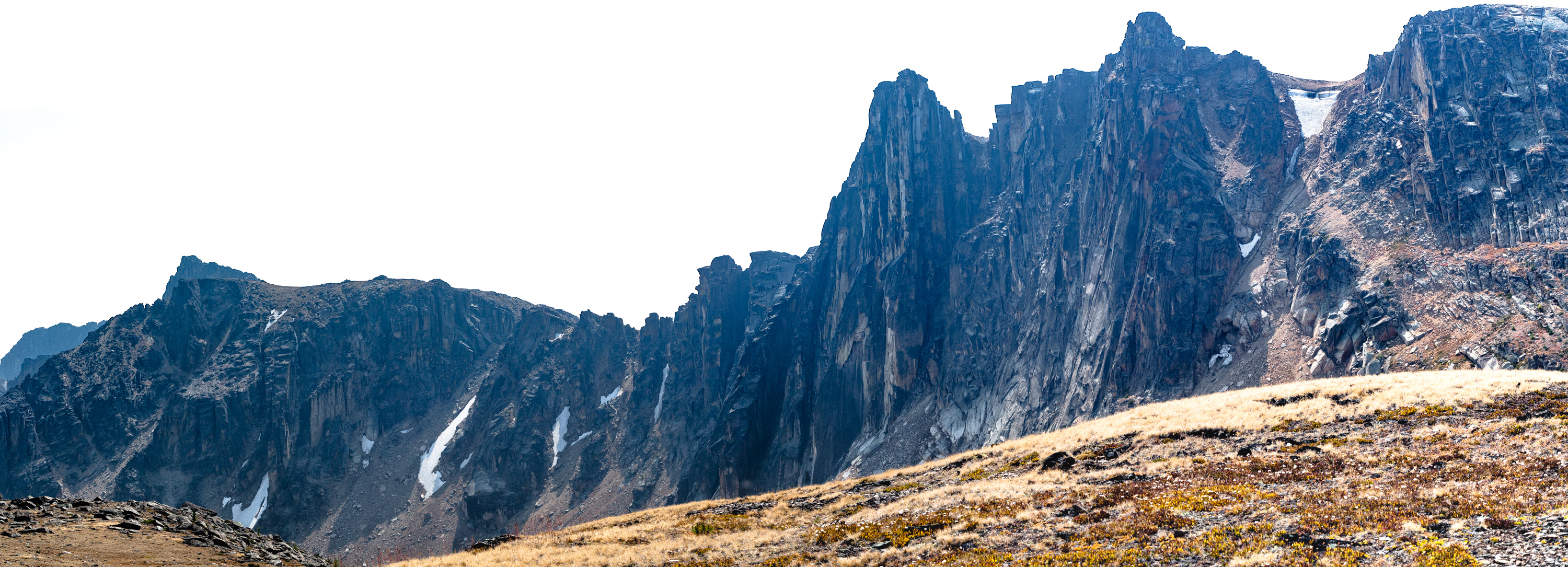
From the map I knew that the lake would be surrounded by a bunch of peaks and nestled into a basin.  Every now and then, I would get a glimpse of where I was ultimately headed.

Beetle's legacy-1
First views of some of the peaks around Goat Lake

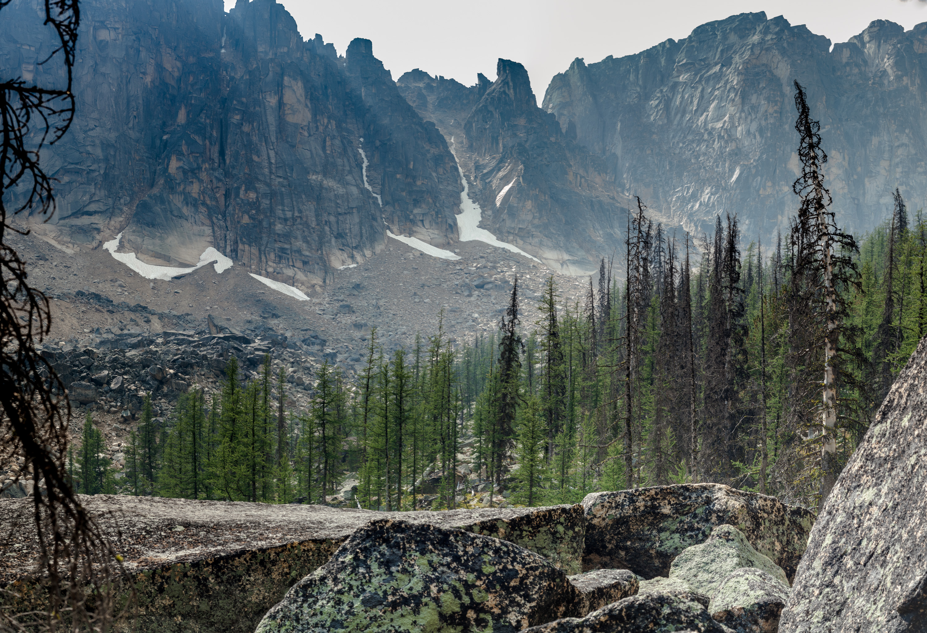
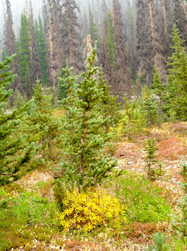
And you can now begin to see some of the devastation caused by the bark beetle.  Most of the large spruce etc are dead.  Fortunately, there are young trees springing up to replace them so in another 30 years or so, if they survive, it won’t look quite so desolate.  You can also see the continuing effects the smoke was having on the views.  Normally would have been clear blue sky with high definition on the mountains given the lens I was using.

mountains and trees-1

stream meadow pano-1
the stream winding through the valley that issues out of Goat Lake.
tenacity-1
I called this image “tenacity”. It will take a good long while for the new ones to attain such a majestic state but I’m hoping they’re tenacious.
Rebirth-1
and this one “rebirth” because you can see all the new trees coming up to replace the dead ones.

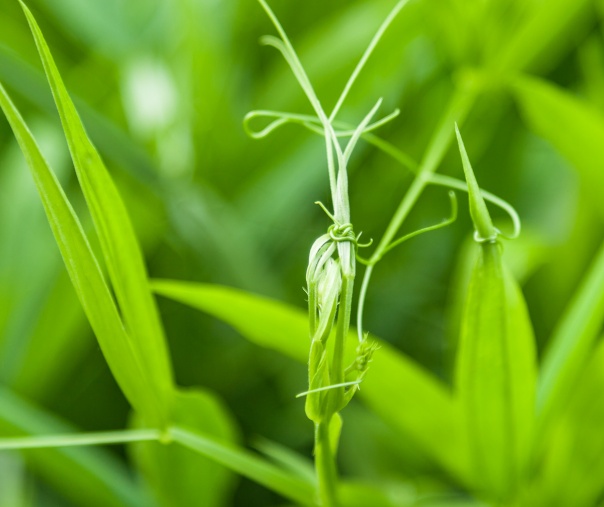
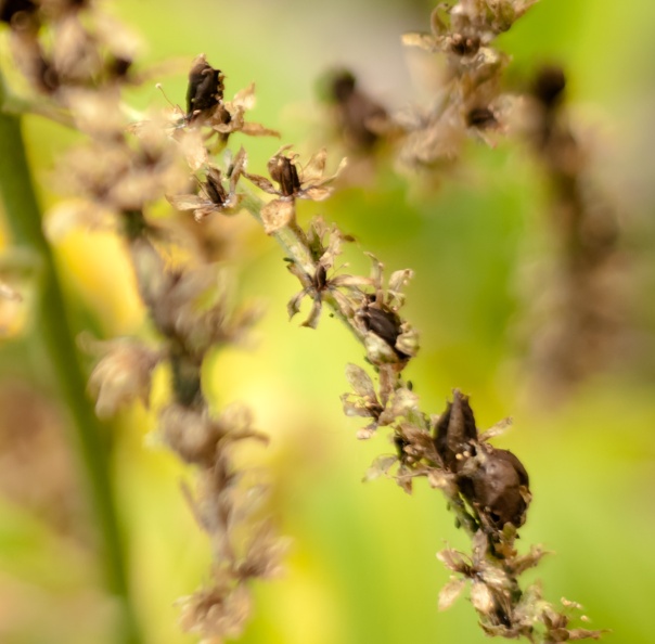
Here’s a lovely boggy meadow filled with a sedge called narrow-leaved cotton grass and then a closeup of the actual cotton grass plant.

Rebirth-2
More peaks coming into view and a lovely bunch of cotton grass
cotton grass-1
cotton grass up close and personal.

Getting a bit closer to the lake now.

mountain meadow pano-1
More of the mountain you saw in the previous picture with all the cotton grass
full mountain pano-1
A panorama preview of what’s coming up around the lake!

And, tada! Finally made it to the lake.

Trail into Goat lake pano-1

It was a warm lovely day except for the smoke so I walked around to the other end of the lake and found a great spot from which to view both the surrounding mountains and the lake while I ate my lunch and drank my tea.  Nice breeze to keep the bugs away, too. Happy camper I am.

goat basin pano-1
Looking South from my lunch spot
Mountain Basin pano-1
More views South.  This is called Denture ridge.
Goat lake pano-1
Looking North across the lake
Goat lake pano-2
The boggy area between the lake and the mountains surrounding it. I was eating lunch perched on a big rock in the trees on the right hand side of the image.

So…. Goat lake is just a nice little lake.  Nothing special about it except for where it is and the peaks that surround it.  There were 2 other young folks there and they left before I did so I had the place all to myself for quite a nice bit of time.

Goat lake larch-1
A lovely larch tree
mountain and trees pano-1
The mountain furthest South and East along the lake’s border.

I just love the rock that these mountains are composed of.  It’s quite dramatic looking and it looks like it would be really fun to scramble up and climb if you were so inclined. Of course, much steeper than it looks in the photos!

After relaxing and taking a few more pictures, it’s time to head back.  A parting shot of the lake on my way back out.

Goat lake pano-3

Took a few more photos of flowers and such.

hellebore flower-1
False Hellebore
early death-1
A dead young spruce.  Not just the old ones are killed.
fall lupine leaves-1
Alpine Lupine leaves in their yellow fall coloration
flower-1
One of the Sparganium spp, probably emersum or angustifolium.
white brown lichen-1
A lichen I’d never seen before!  Really cool colours.  Couldn’t find it looking in Plants of Coastal British Columbia is but checked with a lichen expert and he suggested might be Solorina crocea, chocolate chip lichen.
bryoria lichen macro-1
Another common lichen often found on dead larch and which we saw a lot of, is called tree hair lichen or black tree lichen.  Bryoria fremontii

Made it back to camp and joined up with J and S.  Sponged off my sweat in Lake of the Woods, ate dinner and relaxed.  Watched stars, fell asleep.

Day 3

We had originally planned to leave on the 3:30 shuttle down so after a lazy breakfast we packed up camp and figured we could just leave our gear at the lodge and go for a day hike, returning just a bit before heading out.

Nope.  As I mentioned in the previous post, due to the smoke coming into the park, BC Parks declared an evacuation of Cathedral Lakes Park.  So we pared down our hike to a short jaunt over to Scout Lake which was just a km or so from the lodge and hoped we could get out on the 1 pm shuttle.  No sense hanging around for more smoke!

Turned out to be a good plan.  Wandered over to Scout lake and enjoyed ourselves and saw another of the lakes.  Here’s a few pics.

Scout lake pano-2
Our original day plan was to hike up that far ridge but due to the evac, just went to the lake.
Scout lake pano-1
Another view of the surrounding mountains from the other side of the lake.

I walked all the way around while J and S just stayed on one side.  Here’s a nice sedge that I saw at the lake.

sedge macro-3
Carex stylosa? Variegated or Long-styled sedge is my current best guess and if so is a rare plant.

And a nice batch of Arnica next to a rock.

yellow flowers and rock-1
I think this is Arnica montana or Arnica mollis

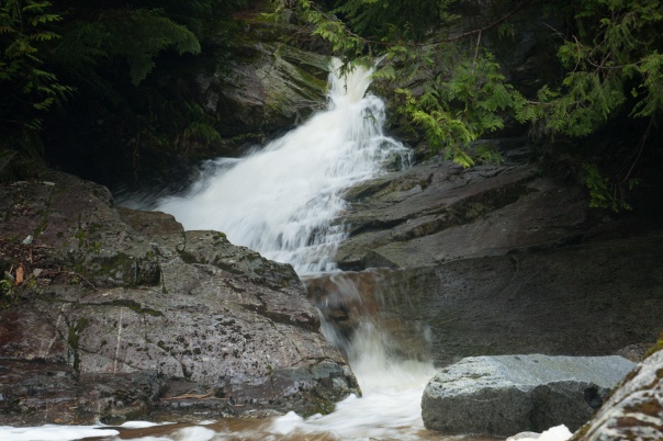
On the way out I went a little way past the lake to see the creek coming out of it and got a really nice shot.

Scout creek-1

It’s very peaceful looking, don’t you think?

Back to the lodge and it turns out that they decided to try to evacuate everyone on the 1pm shuttle.  So they had 3 or 4 trucks going back down to the highway.  Uneventful ride, back to the car and then back home.

So that’s our trip to Cathedral Lakes Provincial Park.  Maybe we’ll go back when there isn’t any smoke and see all the wonderful views we were supposed to see originally.  But there are just so many wonderful places to visit, that maybe we won’t.  Only time will tell.

Hope you enjoyed seeing a bit of this wonderful park.  We sure did!

Until next time, keep on rambling.

Rich

Cathedral Lakes Park: Up in Smoke! Day 1

I finally got to tick off a park that has long been on my bucket list, Cathedral Lakes Provincial Park.  We had planned to go earlier in the summer and had paid and reserved our ride up but cancelled at the last minute because of all the smoke from forest fires in the area.  Instead we went to Manning Park and had a great 3 day backpack with only a bit of smoky views the first day which cleared up nicely for the rest of the trip.

As it was getting near the end of summer, and we still wanted to go to Cathedral, we decided to head up last week.  Smoke reports were pretty low and lodge staff said weather up in the park was great.  So off we went on Sunday to go up on the 4PM shuttle figuring smoke wasn’t going to be in the picture.  WRONG!

It was interesting just how the smoke behaved.  It was coming up from Washington state fires and would come in during the day.  Then the winds would die down and we would have perfectly clear skies to star gaze at night.  Early mornings would look clear blue skies and then the wind would start to pick up and the smoke would move in.

We had planned 3 nights camping and coming back mid-afternoon on day 4.  And that’s what we did, with a little “wrinkle”.  We had reserved our ride out for the 3:30 shuttle but  due to the smoke, it turned out that the park was told to evacuate everyone on that day.  So we all headed down on the 1 PM shuttle, a couple of hours early.

Still, we got in some great hiking and interesting views.  The smoky skies combined with all the dead spruce from the spruce bark beetle kill made for some very other-worldly landscapes.  We felt like we could be on another planet, definitely not in BC!

I really enjoyed looking at the stars while falling asleep on Sunday night. We left the rainfly off the tent and had a clear view through the bug netting.  Monday was our first and most strenuous day of hiking. Got up and had a leisurely camp breakfast.  Lake of the Woods looked lovely. (Many of these photos are large panoramic stitches and you’ll only get the full meal deal if you click on them to view!)

lake of the woods pano-1
Lake of the Woods with Pyramid and Quiniscoe Mts in the background.

Didn’t see any smoke yet.  Plan for the day was to hike to Ladyslipper Lake and then up to the Rim, entering at Stone City.  Here’s a map of the park and the core area. It was only a 250 metre climb to the Lake but we noticed that our energy was lower than usual.  Well, the park and Lake of the Woods is at 2000 metres elevation so that might have had something to do with it!

Here we are coming down into Ladyslipper Lake.

Ladyslitpper pano-1
Coming down to Ladyslipper Lake

For some reason, I got the map turned around in my head and when we got to the lake, we headed off along the North shore to the West end of the lake.  Lots of people at the lake fishing and swimming.

Ladyslitpper pano-2
Here’s the view looking back where we had been at the West end of the lake

We considered trying to make our way up to the rim through that terrain you’re looking at and decided not to.  Retraced our way back to where we turned right and should have turned left and around and up we went.  A view on the way back.

Ladyslitpper pano-3

It was a pretty hot day and we started up the trail to the rim.  We stopped to eat on the way up.

approach rim-2
View from our lunch spot
approach rim-3
closeup view of some really nice rock formations come off the rim

After eating, headed back onto the trail.  Here we are almost up on the rim.

approach rim-1
You can see where we have to go to get up on the rim. S and J heading up.
Walking the rim-1
Almost there!  S and J coming into Stone City

And you can see that the skies are no longer blue but the wind is now bringing the smoke up.  Notice how much darker it is on the right than the left!

Finally made it to Stone City.

Stone city-1
You can see the effects the smoke was having on the views which were severely cut off!
Stone city pano-2
Still, Stone City is an interesting landscape and with the smoke, really starting to look alien.

Stone city pano-1

Star Trek or other space movies would have had a great time filming up here!

smoky rim shot-1

From Stone City we wandered Northwards along the rim to the Devil’s Woodpile.  Love the orange lichens and other vegetation.

pre stone city pano-1We’re now at about 2400 metres elevationRim pano-2

We loved this beautiful wide bench meadow.  The colours are just so understated and subtle.  And the smoke made it look so other worldly.

smoky rim pano-1

S standing on top of the Devil’s Woodpile

Sarah at Woodpile-1
South side of the Devil’s Woodpile

From here we continued along the rim to the trail down to Glacier Lake

Devil's Woodpile-1
North side of the Devil’s Woodpile looking back along the rim where we came from

The trail down to Glacier Lake.  It was much more friendly than the trail up from Ladyslipper Lake and is the way most people get up on the rim if they leave from the lodge.

Glacier Lake pano-1
Heading down to Glacier Lake

Another view of Pyramid Mountain as we head back down.  Notice the sharp division between the smoky sky and not so smoky sky, and the colour of the sun, the white dot at the upper right in the smoke.  To our eyes, it was actually a glowing red ball.  Don’t quite know why it didn’t come out that way in the photo.  Something to do with what lenses see vs what eyes see.

smoky sun pano-1
Pyramid Mountain

It was a full day of hiking.  You can see the stats from my watch, here.  Once back at camp, we relaxed, did a bit of swimming in Lake of the Woods to get the sweat off and really enjoyed eating our dinner.

Stay tuned for Day 2, coming your way in the not too distant future.

Rich 


Finding my niche: The BIG Picture

I’ve always wondered just where I “fit” photographically.  There are so many superb picture takers and image makers out there.  And I have been inspired by all of them.

Recently, I realized what I really like to shoot.  First and foremost, I’m a landscape photographer.  I love shooting macros too, but taking pictures of people, NOT!  I can do it, just doesn’t churn my butter, as they say.

After many years of shooting landscapes, I realized what I really liked doing, and was pretty good at, was putting together panoramas.  I seem to have an eye for just what needs to be in there to make it both a big picture and still retain all the elements that make a photo interesting.

So, expect to see lots of panoramas of places I have been.  And I hope you enjoy them as much as I do.  Here’s a couple from our trip to Quadra Island this past July.

rocky beach pano-1
Walking Rebecca Spit on Quadra Island, BC
Quadra beach D1pano-3
Sunset view of the Coast Mountains from Rebecca Spit on Quadra Island

Click on them to get the BIG picture 🙂

Till next time,

Rich


Gushing

This past weekend, J and I headed into the Burke Mt area with a couple of friends to spend some time hiking and viewing a couple of waterfalls.  The forecast was for clouds and the occasional shower.  Luckily, we got the clouds but not the showers.

Our objectives were the Dry Crossing and Sawblade Falls, both on Coho Creek which tumbles down between a couple of unnamed peaks in Pinecone Burke Provincial Park.

The hike goes up several shared use hiker-mountain biker paths and old logging roads through several different forested areas with lots of lovely spring flowers along the trails, the most common being false solomon’s seal, star-flowered false solomon’s seal, foam flower, bunchberry, and yellow wood violets.

As it was a bit cool for the season, we also lucked out in not being bothered to any serious degree by our insect friends, although the occasional black fly needed brushing off.  After a couple of hours we got to our first waterfall, Dry Crossing Falls.  2 waterfalls hike-12 waterfalls hike-22 waterfalls hike-3

One of the reasons we picked this hike was because we are still in the Spring run off season here in SW British Columbia and the waterfalls are just gushing spectacular amounts of water.  A couple of creek crossings which in summer would be easily transversed required high level ballet type balancing to avoid serious foot and leg soaking!  Not to mention avoiding the algae covered slippery rocks!!

From Dry Crossing Falls, we followed a rough route, the Sawblade Bike Trail, further downstream to arrive at what is becoming a fairly common local hiking destination, Sawblade Falls.  About 30 minutes or so and we arrived at Sawblade falls.  2 waterfalls hike-42 waterfalls hike-5

Our plan was to eat lunch at Sawblade Falls and then head over to a couple of other falls on the way back to the car.  What with the cooler weather, and a strong wet cool spray coming off the falls, we found a less exposed area behind a few trees where we could hear them but not see them and hunkered down and enjoyed our lunch. Here’s a video I took of the falls before we ate.

After lunch, and enjoying a last bit of falls viewing, we decided to forego the other falls and made our way back to the car to conclude a lovely day spent with friends and falls.  A parting shot of Sawblade falls as we head back out.2 waterfalls hike-6

Just a bit of warning; if you’ve never hiked this area before, most of these hikes start at a gate that is just a few hundred metres from a gun club so you often hear loud blasts of gunfire while you’re walking.  But once you get far enough along, the gunshots diminish and forest sounds take over.

And just because you’ve been so patient, here’s another gusher we visited a few weeks ago in the Squamish area, Crooked Falls.  Check out this video, too.crooked falls-1

We do like our waterfalls and there are so many lovely ones here in BC.

Until next time,

keep rambling.

Rich